Utah is a place for all seasons, except summer. From June through August, Utah’s famous canyon country is hot and crowded, but visit in the autumn, winter or spring and you’ll find pockets of desert solitude among the sunny yellow cottonwoods, snow-covered red rocks and colourful spring wildflowers.
Zion national park
In a state that has more parks than it does major cities, Zion stands above the rest as Utah’s first national park and its most visited. The valley floor can get crowded with people, but private cars are restricted in favour of free shuttles, which helps quiet the chaos.
Only a fraction of the park can be seen from the road. This is a place for explorers: more than 100 miles of trails lead from the valley into the narrow river canyons to the north and up the towering red and tan walls of Navajo sandstone to the east and west. A paradise for canyoneers and rock climbers, Zion boasts rock formations spanning more than 150 million years of geologic history.
The park has three developed campgrounds and offers backcountry camping permits to backpackers. Or you can stay at the Zion Lodge (reservations recommended) or in nearby Springdale and around St George.
Top tip The hike up Angels Landing is not for the faint of heart, but it’s worth every vertiginous step. The trail follows a set of chains up a narrow ridge of sandstone to a spectacular summit that looks straight down through the heart of Zion. This route is best attempted in the spring or fall, when it’s likely to be free of summer hoards, or winter snow and ice.
Canyonlands national park
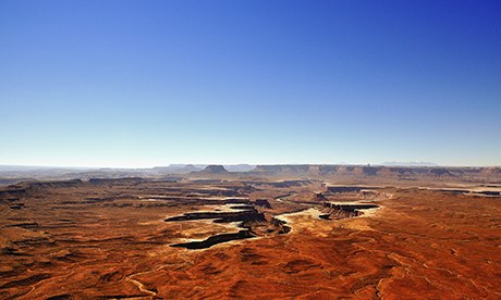
Green River Overlook, Canyonlands national park. Photograph: Mark C Stevens/Getty Images/Flickr RF
The south-west desert is known for out-of-this-world landscapes – some places look like the moon, others like Mars – but Utah’s Canyonlands is an otherworldly place like no other. Here countless canyons, buttes and mesas are carved into a topography so intricate that you find yourself wandering through places with names such as the Maze, the Needles and Island in the Sky.
Canyonlands is Utah’s largest park. You could spend a lifetime exploring the land between the Colorado and the Green rivers and still not reach all the way into the park’s red depths. Tour companies based in Moab offer Jeep tours, hiking, rafting, kayaking, rock climbing, canyoneering, mountain biking, BASE jumping, skydiving, hang gliding, extreme rope swings … you name it, Canyonlands has it.
No matter what kind of adventure you tackle, be sure to stay overnight and catch sunset, the stars and sunrise over the vast maze of red rocks. The park has two developed campgrounds and free dispersed camping can be found nearby. For hotels and hostels, stay in Moab or Blanding.
Top tip Visit a geologic mystery at Upheaval Dome. This massive, almost perfectly round rock formation is either an impact crater from a meteor or an uplifted, eroded salt dome. Either way, it’s a fantastic place for a hike in the Island in the Sky district of Canyonlands.
Capitol Reef national park
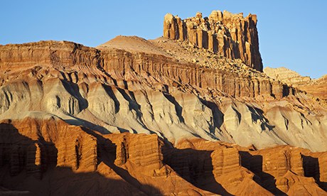
The Castle, Capitol Reef national park. Photograph: Christian Heinrich/Getty Images/Imagebroker RF
Capitol Reef is a narrow park, less than 20 miles wide, but over 100 miles long, which protects the Waterpocket Fold, an awesome S-shaped warp in the Earth’s crust that was created over 65 million years ago by the same forces that built the Rocky Mountains. It’s the longest exposed “monocline” in the world, but you don’t have to be a geologist to appreciate Capitol Reef’s amazing rocks.
The park is named after its series of domes and cliffs, eroded into white Navajo sandstone, which somewhat resemble the US Capitol building in Washington DC. The reef part of the name is a throwback to pioneer days, when settlers were forced to detour all the way around the Waterpocket Fold, which remains all but impassible even today.
A few four-wheel drive roads run into the park, but this place is best seen on foot. Start at the visitor centre (open year-round) and head either north to Cathedral Valley or south into the Waterpocket Fold area. The park has a campground and rooms can be found in nearby Torrey and along highway 12, towards Boulder.
Top tip The Upper Muley Twist Canyon cuts lengthwise along the tilted spine of the Waterpocket Fold, making for a rugged but stunning 15-mile overnight loop hike. Free backcountry camping permits are available in the visitor centre.
Dead Horse Point state park
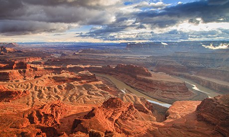
Sunset at Dead Horse Point. Photograph: Matthew Crowley Photography/Getty Images/Flickr RF
Most people flock to the Moab area to visit Arches national park, but this morbidly named gem of a state park is much quieter and possibly even more scenic. Located south and west of Arches, Dead Horse Point is a narrow 2,000-ft high promontory that overlooks the northern reaches of Canyonlands national park.
Back in the 19th century, cowboys used the point as a natural corral, where they could herd mustangs out to the tip and build a fence across the bottleneck of the point. Then they could pick and choose the best horses from the bunch and let the others go. As the story goes, on one occasion the cowboys forgot to open the gate and the remaining horses all died of thirst out on the point, within view of the Colorado river below but trapped by precipitous cliffs.
Tents and motorhomes are allowed at the Dead Horse Point campground and dispersed sites can be found outside the park. Hotel rooms and hostel beds can be found 30 miles away in Moab.
Top tip You can drive all the way out to the edge of Dead Horse Point, but why drive when the walk is among the most spectacular in the south-west? The three-mile Rim Trail starts at the visitor centre and skirts the edge of the point, overlooking the meandering Colorado river, Canyonlands, La Sal mountains and, on a clear day, most of south-east Utah.
Kodachrome Basin state park
Kodachrome Basin. Photograph: Michael Busselle/Getty Images
With a name like Kodachrome, you know this is a place that begs to be photographed. Named by the members of a National Geographic expedition in 1949, Kodachrome Basin looks a bit what Yellowstone national park might look like if all its thermal water features dried up. Here, ancient hot springs and geysers have solidified into an array of beautiful and bizarre rock features called sand pipes.
Located just east of the more famous (and often overcrowded) Bryce Canyon, Kodachrome offers a quieter alternative. Due to its remote location and low light pollution, the night sky here is known for being one of the best in the west and the area’s high elevation often means cooler temperatures here than elsewhere in Utah, making this park a good choice for summer trips.
Top tip Just down the road from Kodachrome Basin is the Grosvenor Arch, an unusual double arch high up on a colourful canyon wall that serves as a symbolic gateway to Grand Staircase Escalante national monument (see below).
Natural Bridges national monument
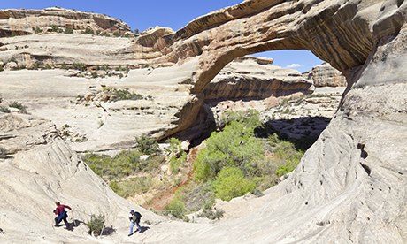
White Canyon, Natural Bridges national monument. Photograph: Pritz Pritz/Getty Images/F1online RM
In geologic terms, the difference between an arch and a natural bridge is water. The former is carved by wind and ice, while the latter is sculpted by a waterway. Three of the most spectacular examples of natural bridges can be found in south-east Utah, just west of Blanding at Natural Bridges national monument.
Here, three majestic bridges, named Kachina, Owachomo and Sipapu, span the White and Anderson canyons. Sipapu, a Hopi name that celebrates the traditional portal through which the First People emerged into the present world, is the largest of the three and one of the longest natural bridges in the world. Evidence for at least two collapsed bridges are found within the park.
All three spans can be viewed from overlooks, with trails leading down to each bridge. The trail to Owachomo is an easy half-mile round trip, while the climb down to Sipapu is considerably steeper and negotiates stairs and three ladders. Camping is available inside the park.
Top tip All three bridges can be linked by a 8½-mile loop that runs through the bottom of the White and Armstrong canyons, making for a nice all-day trek.
Edge of the Cedars state park
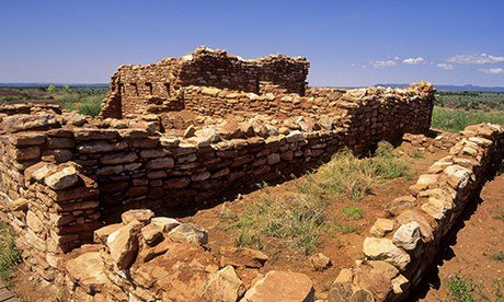
Ruins of an Anasazi pueblo Cedars state park, Utah Photograph: Alamy
Utah has a long, colourful history of human habitation, as evidenced by ruins, petroglyphs and relics left behind by the Ancestral Puebloan, Hopi, Ute and Navajo people. Edge of the Cedars state park in Blanding has a museum featuring the an impressive archaeological repository, plus the ruins of a Puebloan village.
The name Edge of the Cedars come from the park’s location between the densely forested Manti-La Sal national forest and the treeless desert to the east, a prime habitat for early human settlement. The Bears Ears area, situated around two rounded humps of rock shaped like a bear’s ears, inspires many mysteries and local legends.
Blanding is also home to the Blanding Dinosaur Museum, which features rotating exhibits on Utah’s rich Mesozoic history, including fossilised eggs and baby dinosaurs. As the largest town in south-east Utah, Blanding makes for a good base for exploring the region.
Top tip Be sure to check the Edge of the Cedars museum website for lectures, festivals and other events.
Goblin Valley state park
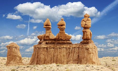
Goblin Valley. Photograph: Dibrova/Getty Images/Flickr RF
In a state rife with geologic oddities, Goblin Valley state park, near Hanksville, sets a high bar for bizarre rock formations. Here thousands of mushroom-shaped hoodoos sit clustered in a secluded valley on the edge of the spectacular San Rafael Swell. The strangely shaped rocks are eroded out of entrada sandstone, a reddish rock that dates to the time of the dinosaurs and underlies much of south-east Utah.
Goblin Valley boasts a campground with hot showers, a rarity in this dry desert state. Campsites tend to fill up fast on weekends, so reservations are recommended. Campground full? Stay outside the park at one of many free campsites, along the swell.
Top tip Three marked hiking trails wind through Goblin Valley, but this is a place for wandering. Keep your bearings – the visitor centre is easy to spot from any vantage – and let yourself get lost between the hoodoos.
Goosenecks state park and Valley of the Gods
Goosenecks state park. Photograph: Panoramic Images/Getty Images/Panoramic Images
South-east Utah is canyon country, with the Green, Colorado and San Juan rivers cutting sinuous and spectacular routes down through red, white and orange bedrock. Goosenecks state park, near Mexican Hat, boasts one of the best overlooks showcasing the power of rivers over rock. Here the entrenched curves of the San Juan river nearly double back on themselves, exposing millions of layers of geologic history.
To the east lies the Valley of the Gods, a pocket of spectacular scenery featuring mesas and buttes reminiscent of the more famous Monument Valley, to the south. A 17-mile road, bumpy but passable to most vehicles when dry, loops through the area, between highways 261 and 163.
As far as state parks go, Goosenecks is pretty primitive, but the scenery makes up for the lack of amenities, including no running water. More developed accommodation can be found in the nearby towns of Bluff and Blanding.
Top tip: Seeking solitude? Park at the main overlook at Goosenecks and hike south and west along the old, increasingly rutted road for about a mile out to the tip of the mesa.
Flaming Gorge national recreation area
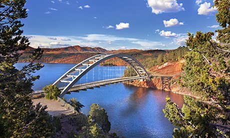
Cart Creek Bridge at Flaming Gorge. Photograph: Jodi Jacobson/Getty Images
In the sweltering summer months, head to the Flaming Gorge, north of Vernal, on the Wyoming border. Here the Flaming Gorge dam holds back the Green river, creating a massive cool, blue reservoir surrounded by towering red walls. Fishing, boating, swimming and water sports are popular year-round, and five marinas rent kayaks, canoes and rafts.
The Flaming Gorge is also know for its endless backpacking options. Treks ranging from easy overnights to multi-week adventures can be found in the nearby Uinta mountains, Ashley and Wasatch-Cache national forests, including 13,528-ft Kings Peak, the highest mountain in Utah.
Camping opportunities abound, ranging from all-inclusive RV resorts to rustic cabins and remote tent sites. Hotel rooms and other accommodations can be found in Vernal, home to the Utah Field House of Natural History and close to Dinosaur National Monument, another gem for dinosaur-lovers.
Top tip The waters of the Flaming Gorge reservoir are famous for growing massive trophy trout, some as big as 13kg! Tie a fly on yourself or book a local guide.
Mary Caperton Morton is a freelance writer and photographer who makes her home on the back roads of North America, living and working out of a tiny solar-powered camper
//FACEBOOK COMMENT by JETZTKAUFEN.INFO - best online store


